|
Wheat Update

DR. TYSON RAPER
JACKSON, TENN.
Last week was beautiful. As we were all in the midst of figuring out life during unprecedented times, nature appeared to thumb her nose at the COVID-19 pandemic; dogwoods in full bloom, crappie moving into shallow water, tree shaking gobbles echoing through t-shirt temperature mornings. But after almost a week of beautiful weather in West Tennessee, Easter brought a cold and unfortunately hazardous front through the area that will likely stay with us through the week. As I write this on Monday, the forecast for nighttime temperatures sits in the mid to lower 30s for the next several days. These temperatures likely summon difficult memories of the Easter Freeze of 2007. With that in mind, I wanted to pass along a little information that will hopefully put you at ease.
Wheat fields I’ve walked over the past week range from Feekes 8-10.5, with the majority of fields in boot. Based on what we know about cold tolerance, cold damage to wheat will likely not occur in the boot stage (or the stages immediately prior to or after boot) unless temps fall below 30 degrees for a considerable amount of time. Please find a figure below from Dr. Robert Klein’s, ‘EC132: Freeze injury to Nebraska Wheat.’ At this time, our forecast does not include those temperatures. Our forecast does, however, include clear, sunny skies by the end of the week. You’ve probably heard an agronomist at some point in your career mention the flag leaf is very important in filling the head- it is estimated that somewhere close to 75 percent of the photosynthate used in grain fill originates from the flag leaf. I want that flag leaf to see as much sun as possible in the coming weeks, and the end of this week looks very good.
Concerning rainfall- during Lindsay Stephenson’s wheat update two weeks ago, several mentioned excessive spring rain as a likely yield-limiting factor for Tennessee wheat, but that excessive spring rain over the past several seasons has not drastically reduced yields. I firmly believe a drier April and May will support the highest yielding wheat. But I suspect we have not seen a major drag from the excessive rains because of the length of these events. In the past few years, we have observed more intense rainfall events. For example, we received over 2” in Jackson on Easter Sunday. That event saturated soils and resulted in runoff. After that event, however, it appears that we will have several drying days with soils likely holding near field capacity. Even though these large events keep us out of the fields for a considerable amount of time, I believe they have less of a negative impact on wheat yield than several consecutive days of light rains which keep our soils at saturation for a prolonged period of time.
One other item- Dr. Heather Kelly just posted a wheat fungicide blog that can be found. Even with cool temperatures, sunlight will push us rapidly toward possible fungicide applications targeting fusarium head blight. Stay-tuned in the coming weeks for updates from Dr. Kelly on disease progression, timing and fungicide efficacy. ∆
DR. TYSON RAPER: Cotton & Small Grains Specialist, University of Tennessee
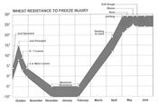
Figure from Dr. Robert Klein’s, ‘EC132: Freeze injury to Nebraska Wheat’.
|
|