|
Delta Soils Of Southeast Missouri
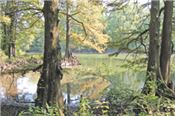
Figure 1. The Delta land was called the Great Swamp because the land was covered in water most of the year.
Photo is a natural oxbow lake surrounded by cypress forest in the Wolf Bayou Conservation Area near Hayti, Missouri. The lake is an old bend
in the Mississippi River which changed course and no longer flows through the loop.
DR. GENE STEVENS
PORTAGEVILLE, MO.
Part One Of A Multiple Part Series
The upper Mississippi River alluvial valley is called the Delta region. The Delta includes parts of Missouri, Tennessee, Arkansas, Mississippi, and Louisiana. This report will focus on the upper Delta in Southeast Missouri. It is one of the most fertile places for growing crops in the United States. The high crop productivity is due to the soils, climate, and abundant ground water for irrigation. Delta soils were formed by alluvial sediments from the Mississippi and Ohio Rivers and smaller rivers from the Ozark Highlands. Temperatures in the growing season are warm enough for producing cotton and rice but also suited for producing high corn and soybean yields. Farmers often apply water with furrow and center pivot irrigation systems during periods of low rainfall.
The purpose of this report is to describe the different kinds of soils and their location in the Delta, explain how they were formed, and evaluate their potential for production and adaptation to different crops.
The Delta is an alluvial valley of recent geological age. Soils are usually in the early stages of weathering with slight to moderate horizon development. When alluvial material was deposited, sediments often varied due to shifts in stream channels, sometimes with clay over sand and vice versa.
Farmers should remember that the present prosperity of the region was preceded by the toil and struggle of the pioneers who cleared the land and constructed the first drainage ditches. There were many failures in capital investment for reclamation before the land became productive. The physical, agricultural, and cultural development of the Delta forms a special chapter in the history of Missouri.
A Distinct Agricultural Region
The Delta Region in Southeast Missouri is the northern end of the Mississippi alluvial valley. It includes all or part of 11 counties: Bollinger, Butler, Cape Girardeau, Dunklin, Mississippi, New Madrid, Pemiscot, Ripley, Scott, Stoddard, and Wayne. The total area is about 3,900 square miles, or 2,509,000 acres. The physical boundaries are defined on the east by the Mississippi River and on the west by the Ozark Escarpment. At the Escarpment, an abrupt drop in elevation occurs where the hills of the Ozarks meet the level alluvial plain of the Delta.
Southeast Missouri was once called the “Big Swamp” (Figure 1). The town of New Madrid was founded by Spain in 1778. Few people lived in the region because of the land was in covered in water most of the year. In 1803, the Delta became part of the United States with the Louisiana Purchase from France. Earthquakes in 1811 and 1812 caused stream banks to collapse which further reduced water drainage. The region had many sand sloughs, river swamps, and small lakes. Traveling in the region was difficult for people and mosquitoes were vectors for spreading disease. Lumbering was a major industry from 1890 to 1930. In 1840 there was an influx of German immigrants, but the greatest increase in population has occurred since 1910. The transformation of the Delta into farmland increased after the Little River Drainage System was constructed and the area of cultivated land increased from an estimated 600,000 acres in 1900, to more than 1,800,000 acres in 1960.
Many changes have occurred over the last 175 years. The early economy was based on harvesting timber and the lumber was moved to outside markets by railroads. As the number of large trees declined, row crop farming became important. Over the following decades, agriculture transitioned from sharecrop farming to commercial operations. The number of farms decreased while farm size increased. Tractors replaced mules and field equipment increased in size. Herbicides replaced laborers chopping weeds. To effectively manage more land area, farmers began using crop consultants and scouts to monitor fields for pests. The economy of the region is still based on agriculture which is impacted by soils. For example, cotton, corn, and soybean grow best on well-drained soils. Rice is generally flood irrigated and needs soils with enough clay to retain water.
Known by Several Names
Dr. H. H. Krusekopf wrote the first edition of this bulletin in 1966. He preferred Lowlands instead of Delta for the region name. In this edition, Lowlands will be used for sub-regions.
By definition, deltas are the area near the mouth of rivers with active areas of sedimentation. The Mississippi River Delta is unique and does not exactly fit the definition. It is a vast area extending southward 600 miles from Cape Girardeau, Missouri to the Gulf of Mexico. Geologists have hypothesized that in prehistoric times stress in the North American continental plate caused a rift in the upper crust. This created a large trough extending from south of Cape Girardeau to the Gulf of Mexico. Over time glacial periods produced enormous amounts of outwash and the sediment which filled the trough and formed lowlands. The thickness of Delta soils averages more than 125 feet. The deep substratum material consists largely of beds of sand and gravel and is coarser in texture than the upper surface deposits.
Shifts of Rivers
Shifts of the Mississippi and Ohio Rivers altered the land surface to form subareas of the Delta (map on Figure 2). The names assigned to lowland areas were developed by geologists and geographers in 1958. The six subareas listed below are characterized by different soil and drainage conditions.
• Upland-Crowley’s Ridge and Scott County Hills
• Western Lowland
• Advance Lowland
• Kennett and Sikeston Ridges
• Morehouse Lowland-Essex terrace and Little River overflow
• Eastern Lowland-Charleston terrace and Mississippi meander belt
The Mississippi River originally turned west at Cape Girardeau and occupied the Western Lowland between Crowley’s Ridge and the Ozark Highlands. The Ozark Escarpment was the west bank of the Mississippi River. The Ohio River occupied the eastern Lowland south of Scott County Hills and flowed south along the eastern edge of Crowley’s Ridge. At that time, the Scott County Hills and Crowley’s Ridge were a continuous upland and formed the divide between the Mississippi and Ohio Rivers. The junction of the two large rivers was near Helena, Arkansas. Later, the Mississippi River changed course and cut through Crowley’s Ridge, forming a large gap in the upland soils between Bell City and Oran, Missouri. At the time the Kennett Ridge and Sikeston Ridge were connected. Then, the Mississippi River shifted again to occupy Thebes Gap, a gorge north of Commerce, Missouri, and joined the Ohio River near Cairo, Illinois. The combined rivers follow a meandering course south to the state line and beyond to the Gulf of Mexico.
When the Mississippi River abandoned its old channel west of Crowley’s Ridge, the smaller streams from the Ozark Highlands adjusted their courses. The St. Francis River continued to flow southward and eventually cut through Crowley’s Ridge at the Missouri-Arkansas state line, and then occupied the abandoned channel of the Ohio River along the eastern edge of Crowley’s Ridge south of Campbell, Missouri. Castor River shifted from the western Lowland, and occupied a small abandoned valley across the northern part of Crowley’s Ridge from Leora, Missouri to Aquilla, Missouri. Whitewater Creek and Hubble Creek flowed south, and joined Castor River to form the Little River near Morehouse. Castor and Whitewater have been canalized and joined to form the Headwater Diversion Channel. This large artificial channel was built in 1913, flows east, and then joins the Mississippi River about 2 miles south of Cape Girardeau.
Alluvial parent materials of Delta soils are minerals from weathered rocks eroded from the Ozark, the Appalachian, and the Rocky Mountains. Current soil fertility in fields is impacted by the origin of sediments. In the western part of the Delta, alluvial sediment deposits from the Black, St. Francis, and Castor Rivers come from minerals in the Ozark Highlands. Sediment deposits from the Ohio River are produced from rocks from the Appalachian Mountains, an ancient mountain range with layers of deep earth including volcanic rocks near the surface. The Mississippi River joins the Missouri River near St. Charles, Missouri. The Missouri River drains the Rocky Mountains beginning in western Montana. The Rockies have much younger rocks than the Appalachians or Ozarks.
Upland-Crowley’s Ridge and Scott County Hills
Crowley’s Ridge runs north and south and is one to twelve miles wide extending from Scott County, Missouri into eastern Arkansas. (Figure 3). When the Mississippi River abandoned the Advance Lowland, it cut through Crowley’s Ridge south of Scott County Hills. (Figure 4). Before this happened, Crowley’s Ridge and Scott County Hills were one continuous land mass. The Mississippi River created a large gap from Bell City to Oran, Missouri. Land fragments of the old Crowley’s Ridge can be seen today northwest of Bell City. Bird, Cow, Lost and Ringer Hills are isolated hills or knobs and formerly were a part of the main upland.
Western Lowland
The broad, almost level alluvial plain between the Ozark Escarpment and Crowley’s Ridge is the Western Lowland. It extends from Wappapello south to the Arkansas state line. It is the former Mississippi alluvial valley, now occupied by the Black and St. Francis Rivers (Figure 5). The aggraded valley has an elevation over 300 feet, and averages 15 to 25 feet higher than the lowland east of Crowley’s Ridge. With the possible exception of the Kennett and Sikeston Ridges, the alluvial deposits here are older than those in other parts of the Delta.
Advance Lowland
The Advance Lowland includes the northern tip of the Lowland Region. It extends from Cape Girardeau west to the St. Francis River near Wappapello. It is bounded on the north by the Ozark Escarpment, and on the south by Scott County Hills and Crowley’s Ridge. This subarea, like the western Lowland, is the former alluvial valley of the Mississippi River. It has been filled by alluvial deposits of Castor, Whitewater, Hubble and other Ozark streams.
The loess-covered upland supplied vast quantities of sediment that covers and obscures the old drainage lines. The elevation at the town of Delta is 335 feet. The west end of Advance Lowland is blocked by the alluvial fan of the St. Francis River, resulting in the Mingo Swamp. (Figure 6). About 1 mile east of Advance, the former channel of the Mississippi River is marked by natural levees.
Successive terraces conforming to the bend in the river became shorter going east. An unusual bog area is located in the Oran-Bell City Gap. It is probably a remnant of the abandoned Mississippi River channel that has been filled in with organic matter and sediment (Figure 7). ∆
DR. GENE STEVENS: Professor of Plant Science, University of Missouri
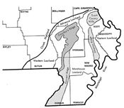
Figure 2. Map of lowlands, ridges, and hills in Southeast Missouri Delta Region (Data source: U.S. Geological Survey).
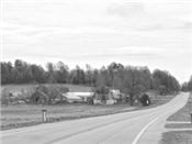
Figure 3. Crowley’s Ridge rises abruptly from the surrounding Delta land to a height of 150 feet.
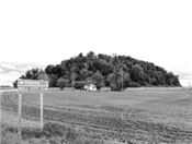
Figure 4. Bird, Cow, and Ringer Hills are isolated land masses previously part of Crowley’s Ridge that survived the Mississippi River cutting through the
Bell City-Oran Gap. Drive east of Advance, Missouri on County Highway O.
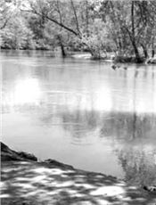
Figure 6. The Mingo Swamp near Puxico, Missouri, is part of the old channel of the Mississippi River before
it shifted course east of Crowley’s Ridge.
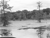
Figure 6. The Mingo Swamp near Puxico, Missouri, is part of the old channel of the Mississippi River before
it shifted course east of Crowley’s Ridge.
Figure 7. The photo shows an area of high organic soils which forms natural bogs surrounded by trees located on Stoddard County Road 347 near Oran, Missouri.
|
|