|
Delta Soils Of Southeast Missouri
DR. GENE STEVENS
PORTAGEVILLE, MO.
Last Part Of A Multiple Part Series
Changes in Soils Due to the Action of Man Significant changes in the morphological properties of the soils have resulted from the action of man by removal of the forest, reduced flooding, extensive drainage, land grading, and frequent cultivation. The development of horizons in soils over time results from accumulation of organic matter, leaching of carbonates and soluble salts, translocation of silicate clay minerals, and reduction and transfer of iron. Farming activities sometime disrupt horizon development.
Most land areas are no longer subject to prolonged floodwater inundation. Land forming or land leveling is a form of soil management that has been adopted in recent years (Figure 20). Its purpose is to eliminate low places and depressions in fields and to provide better surface drainage. The water table has been lowered, reduction processes have been slowed, and aeration extends to a greater depth. Because of better oxidation, many of the light gray soils have acquired a brownish color at the surface. The deep drying of the clay soils has caused them to be more granular, less sticky, and more easily tilled.
Delta farmers often plant crops on beds to promote soil temperature during seed germination and minimize waterlogged soil conditions. In bedded fields, part of the bedded surface is at an angle to the sun most of the day. This increases the amount of heat absorbed by the surface and transmitted to the seed and root level. Also, wind hits a larger area in bedded fields and soil evaporation is increased which helps dry the soil.
The size of fields has increased to accommodate larger field equipment. Farmers are able to plant more acres in a day. The downside is few structures exist to break the wind which is a hazard in the flat Delta terrain. Fence rows and trees along field borders have been removed. Strong winds before storms have caused brown clouds filled with dry soil reminiscent of the Dust Bowl in the Plains. Sand storms in mid-May injured cotton seedlings causing delayed early plant growth in Pemiscot, Dunklin, and New Madrid counties in the 1980’s and early 1990’s. Some fields had to be replanted. Beginning in the late 1990’s, it became common for farmers to plant wheat in the row middles to minimize blowing soils in spring storms (Figure 21).
The removal of the forest and the cultivation of the land has reduced soil organic matter content in soils. The clay soils have become lighter in color and the sandy soils have a greater tendency for compaction or crusting. Protection from flooding by levees and ditches has eliminated sedimentation, especially along the Mississippi and St. Francis Rivers. The greatest change has resulted from drainage.
Conservation tillage, combined with winter cover crops, has helped increase soil microorganisms and earthworms. In some fields, farmers plant winter cover crops for soil health in addition to wind protection (Figure 22). Seed blends include one or more of the following: wheat, rye, radish, rapeseed, Austrian winter peas, hairy vetch, and crimson clover.
Most of the alluvial soils are fertile, deep, and retain productivity under continued cultivation. During the early development period previous to World War II, little effort was made toward soil fertility improvement. The prevailing opinion was that it was not needed. Farmers were more concerned with clearing and draining the land. Where wheat was grown, clover was included for hay and soil improvement. The decline in productivity of sandy soils prompted the greater use of lespedeza, vetch, crimson clover, and crotalaria. Production of these resulted in the use of limestone to a small extent, mainly in Scott and Stoddard Counties.
Before the use of inorganic fertilizers, the soils in the Western Lowlands had the least plant nutrients and produced the lowest yields. Soils east of Crowley’s Ridge were generally more fertile because of more recent sediment deposits. In 1930, potassium fertilizer began to be used on cotton in Dunklin County. At first, fertilizer was used mainly on the sandy soils. The use of fertilizer in the rest of the Delta began following World War II. Crop yields in all lowland subregions increased with the application of inorganic fertilizers. Today, potassium deficiency in crops is more common than phosphorus deficiency.
Anhydrous ammonia, ammonium nitrate, and urea are the main nitrogen sources for crops. The most common nitrogen fertilizer is urea. Compared to ammonium nitrate, urea has a higher percent nitrogen content which reduces freight costs. The downside to urea is that significant nitrogen losses can occur by volatilization when it is broadcast on wet soil. To reduce losses, farmers often pretreat urea with a urease inhibitor stabilizer.
Limestone is used to neutralize soil acidity in fields. Sandy soils are weakly buffered and need liming more often than clay soils. The optimum pH for most crops is 6.5 to 7.0. The availability of aluminum and manganese often reach toxic levels in plants when soil pH is below 5.0. In a rice-soybean rotation, farmers should lime in the year before soybean to avoid zinc deficiency in rice from short term soil alkalinity.
In the past, the conventional wisdom was that enough sulfur becomes available to crops by rainfall deposition or organic matter decomposition. This is less likely to be true today. Reductions in air pollution have increased crop sulfur fertilization. One of the goals of the U.S. Clean Air Act of 1970 was to reduce "acid rain." To comply with Environmental Protection Agency standards for sulfur dioxide gas emissions, many power facilities have switched to burning low-sulfur Western United States subbituminous coal. Sulfur fertilizer is recommended for Delta fields when laboratory soil tests show less than 7.5 parts per million sulfur on soils less than 6.5 CEC (cation exchange capacity).
Crops
Historically, large-scale farming in the Delta region has been limited to crops. Animal production is small compared to the rest of Missouri. Early farmers raised horses and mules to pull wagons and plows and chickens, cows, and pigs for feeding their families. Recently, poultry production has grown in the northern counties. Commercial chicken houses are located near Sikeston and Dexter.
Wheat was one of the first crops grown in the Delta. In the late 1800’s, grain mills for processing wheat were built in Cape Girardeau, Dexter, Charleston, Sikeston, Oran, and Advance. Wheat was formerly a major crop, especially on the sandy acreage in Scott County, but production declined after World War I.
Cotton acreage increased greatly after 1921 and largely replaced wheat. Cotton is a dominant commodity on well-drained soils in Pemiscot, Dunklin, and New Madrid Counties. In wet conditions cotton seedlings are susceptible to root rot (Pythium and Rhizoctonia ). Bosket fine sandy loam, Dundee silt loam, and Dubbs silt loam soil types are important for cotton production in the Senath and Hornersville area. The boll weevil was a major cotton insect pest but was eradicated in a program sponsored by the United States Department of Agriculture (USDA) starting in 2001. Delta farmers are a major producer of fiber for the world despite the loss of the textile industry in the United States. New technologies have been adopted by cotton farmers. Earlier maturing varieties, fertilizers, and irrigation have resulted in increased yields. The use of mechanical pickers and sprayers for weed control changed production methods. The cost of labor for cultivation and harvesting has been reduced, and the time of harvest has been shortened.
Corn and soybean are often grown in rotation to maximize yields and disrupt pest cycles. Year to year fluctuations in planted acres for each crop are due to spring weather, domestic and international market demand, and government programs. Loamy fine sand soils are important soils for growing corn near Charleston, Missouri. On sandy soils, center pivots are used to apply irrigation water. New corn hybrids tolerate more plants per acre. Most of the corn is sold as cash grain crop and processed for commercial animal feed.
Soybean emerged as an important crop in the Delta around 1950. Before then it was mainly grown for hay. It is a versatile crop and can be grown on most Delta soils. Soybean can tolerate waterlogged soils better than cotton and corn. It is often rotated with rice and double cropped with wheat. In New Madrid County the acreage increased from 14,972 in 1940 to 82,946 in 1950, 146,425 in 1960, and 210,000 in 2018. The greatest increase was on the clay soils and on the light-colored soils in the Western Lowland. The soybean cyst nematode is a major pest which reduces yields. The soybean Breeding Program at the Fisher Delta Research Center has released many new varieties with improved disease and soybean cyst nematode resistance.
Rice was not listed as a crop grown in the Missouri Delta in the first edition of this bulletin written in 1966. In 1973, the US Congress lifted acre allotment limits on Missouri rice. Today, Missouri’s annual rice production is usually around 200,000 acres. Rice soils contain enough clay to retain water during flood irrigation. Most of the rice is grown west of Crowley’s Ridge, but production is expanding in fields with Sharkey clay soil using furrow irrigation in other areas. Overcup silt loam and Calhoun silt loam soil types are major rice soils in the Qulin, Missouri, area. These soils have silt loam in the top 8 to 24 inches with silty clay in the subsoil. During tillage, soils with silt loam surface horizons do not form large clods as much as Sharkey clay.
Other important crops in the Delta are watermelons, peaches, potatoes, and purple hull peas. Potatoes are grown on sandy soils and are processed for making potato chips. Peanuts and sweet potatoes are also grown in the Delta.
Irrigation
Irrigation is sustainable in the Delta because of groundwater recharge from rainfall on sandy ridges in the Delta. Water penetration through sandy soil is high in the Kennett Ridge, Charleston and East Prairie areas. The general direction of water movement in the alluvial aquifer is north to south in the Delta region. Groundwater recharge in the Advance and Western Lowlands occurs from the Ozark Highlands where karst topography with sinkholes are prevalent. In a losing stream, water infiltrates into the groundwater as it flows downstream. A tracer study showed that dye introduced into a losing stream was detected 16 days later at Big Spring 40 miles away near Mountain View, Missouri. The amount of groundwater recharge in the Morehouse and Eastern Lowlands from the Ozark Highlands is not known. Deep substratum layers below Crowley’s Ridge may slow west to east water movement in the aquifer.
Irrigation water is applied to corn, cotton, soybean, and rice based on daily crop water use. The method of irrigation depends on the crop planted and the soil properties. Flood irrigation was adopted for the production of rice, mainly on soils with high clay content. Furrow irrigation on other crops became important. Farmers first constructed supply ditches, but these often interfered with normal surface drainage of the field. Then, gated aluminum pipes were used to supply water from wells to furrows. Later, in the early 1990’s, aluminum pipes were replaced by disposable lay-flat plastic tubing (Figure 23). Less labor is required to install plastic tubing and it can be rolled up at the end of the growing season for recycling. To assure uniform distribution of water with furrow irrigation, most fields have been graded.
Center pivot irrigation systems are common especially on sandy soils. The machinery cost for a pivot is more than a furrow system, but, depending on the field, farmers could save money by not land leveling (Figure 24). Most center pivots are programable to turn on and off and can be used with injection pumps for chemigation. Systems have been developed to vary irrigation rates based on different soils in a field.
In the Delta region, water tables are usually below the depth of root penetration. The water table is highest at the Mingo Swamp in the Advance Lowland. Here the underground water from the Ozark Highlands tends to rise in the alluvial material by hydrostatic pressure. A shallow water table, normally more than three feet below the surface, exists in the swales bordering Kennett and Sikeston Ridges, and in the Blodgett sand area.
Climate
The summers in Southeast Missouri are hot and humid, and the winters are usually moderate. Annual average temperature and rainfall are higher than for other parts of the state.
Precipitation averages 49 inches but varies 5 to 10 inches from year to year. Heavy rains in the spring sometimes cause runoff beyond the capacity of drainage ditches. At such times, low lying land may be inundated for several days. Planting is often delayed in wet springs. Dry periods of two to four weeks in duration occur in late summer or early fall, reducing yields, unless irrigation is applied. The very sandy and the gray soils are affected the most by dry weather. Low rainfall is desirable in the fall during harvest. Snow may occur during the three winter months, but usually it is light and does not remain for more than three to five days. Days with below zero degrees Fahrenheit are rare. The prevailing wind in the summer is from the southwest. Hailstorms and tornadoes do occur, but are no more frequent than in any other part of Missouri.
The average date of the last killing freeze in the spring is the last week in March or the first few days in April. The average date of first killing freeze in the fall is about the first of November. The average growing season is more than 200 days, which is adequate for the maturing of cotton and rice. The variation in frost-free days because of late spring frosts from north to south within the Delta is about 10 days. This seemingly small difference is responsible for the smaller cotton acreage north of Sikeston. The generally long growing season permits the maturing of double-crop soybean planted after wheat, and the sowing of winter wheat after cotton harvest.
Transportation
The Delta region of Southeast Missouri has a good infrastructure for moving agricultural freight. Railroads, river barges, and trucks supply bulk inputs such as fertilizer to the area and transport harvested grain and cotton to markets. The Mississippi River has been a means of transportation from pioneer times to the present. Boats from New Orleans traveled the river as far north as St. Louis and beyond.
Port harbors on the Mississippi River provide farmers access to buyers with elevators to load grain on barges. Barges carry grain to the Gulf of Mexico where it is loaded on ships for international markets. Cape Girardeau, Commerce, Cairo, New Madrid and Caruthersville are important river ports where large quantities of agricultural products are shipped to Memphis and New Orleans.
The St. Louis Iron Mountain was the first railroad built, starting about 1858 and completed in 1870. It extended from Bismarck, Missouri in St. Francois County to Belmont, Missouri (this town no longer exists) on the Mississippi River. The Missouri Pacific railroad between Cairo, Illinois and Poplar Bluff, Missouri was completed in 1867.
A rapid extension of railroads occurred after the Civil War. From 1880 to 1920, Louis Houck built 500 miles of railroad tracks networking the Delta region. Over time, small railroad companies in the United States merged and consolidated into seven major railways. Today, Burlington Northern Santa Fe Railway and the Union Pacific Railroad provide freight services in Southeast Missouri. New Orleans and Memphis are the principal markets for cotton, soybeans, oil, corn and wheat.
County, state, and interstate highways help farmers move harvested grain and fiber to markets. Interstate 55 and 57 cross the Delta region and provide truck routes to St, Louis, Memphis, Chicago, and New Orleans.
Summary
Fertile soils, humid climate, level topography, and abundant groundwater aquifers are important factors in crop production in the Delta region of Southeast Missouri. Furrow and center irrigation have been adopted by most farmers to reduce water stress from periods of low rainfall during the summer. If trends continue, farmers will adopt new technologies to increase crop yields and reduce input costs. Mechanization will decrease the demand for labor which means larger farms with fewer growers.
Many Delta soils are classified somewhat poorly drained or poorly drained. Research should continue to develop crop varieties tolerant to waterlogging. Future development of the land must improve surface drainage, maintain soil organic matter and reduce cultivation. Managing fields to conserve crop residues and plant cover crops will improve soil structure and drainage.
Changes in cropping systems have occurred since the land was cleared, levees constructed, and ditches and channels made to prevent flooding. Conditions are favorable for growing many types of crops. This is most apparent in the phenomenal increase in rice and soybean acres. New crops and new varieties will be planted and the intensification of agriculture will depend on careful soil management in the Delta region. ∆
DR. GENE STEVENS: Professor of Plant Science, University of Missouri
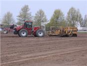
Figure 20. GPS guided land grading is used to improve drainage and uniformity of water application with furrow irrigation.
 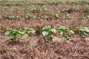
Figure 21. Sand storm near Hayward, Missouri in 1995 (left). Wheat is planted and killed in cotton row middles to reduce blowing sand.
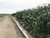
Figure 23. Holes are punched in lay-flat plastic pipe to supply water to row furrows.
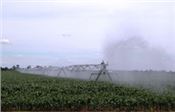
Figure 24. Center pivot irrigation systems use an end gun to apply water beyond the circle.

Figure 22. Residues from winter cover crops are a food source for soil microorganisms and earthworms in Delta fields.
|
|