Drones Beneficial For Surveying Duck Broods
BATON ROUGE, LA.
Researchers with the LSU AgCenter School of Renewable Natural Resources have found using drones equipped with thermal cameras is more effective and efficient in detecting duck broods than the traditional method of using ground surveys when observing nesting areas.
Brood surveys are used to estimate the productivity of ducks. However, ground surveys may underestimate productivity because ducks tend to seek shelter within the vegetation and are unobservable, according to Kevin Ringelman, a waterfowl ecologist in the school.
“With unmanned aerial vehicles, we can see twice as many broods in a third of the time,” Ringelman said. “We suspected we would see more, but we didn’t expect to see twice as many.”
Ringelman and associates surveyed two areas using the traditional method involving a team of trained technicians who would view area wetlands with binoculars from the ground, and a second method using drones with thermal cameras. The two areas were in Manitoba, Canada, and Minnesota.
In Manitoba, 669 broods were found with the drone compared to 344 with the ground survey method.
In Minnesota, 225 duck broods were detected by drone and 105 with the traditional viewing method.
Ringelman said the discrepancy between the two sites was the Minnesota site contained a significant amount of row crop agriculture. This caused the grassland nesting areas to be smaller and more fragmented and produced fewer broods than the Canadian site.
In this study, the drone was fitted with a thermal imaging camera, which allowed the researchers to see the heat signatures of the ducks.
When ducks were spotted, the drone was lowered, and a color photograph was taken. The photo allowed the researchers to better identify the species of the ducks if the hen was present.
Ringelman said that time of day affected the quality and quantity of the data.
“The earlier, the better,” he said. “The sooner you could get out there, the more accurate the data were.”
As the day warmed up, Ringelman said the thermal imaging camera encountered more “noise” from the heat signatures of warming water, vegetation and other objects in the water.
The behavioral patterns of ducks influence their observability.
Dabbling ducks such as blue-winged teal, mallards and gadwall tend to stay near or in thick vegetation, especially when they feel threatened. Diving ducks such as canvasbacks, ring-necked and redheads tend to go to the deepest part of the pond because they dive and swim as an escape tactic, making divers more likely to be observed.
While there was an upfront initial cost in purchasing the drone, Ringelman indicated that it could pay for itself.
“It takes three times as many people to do ground surveys,” he said. “And the data are not as good.”
The information gained from this study could help provide some insight into what makes some wetland areas more productive than others, Ringelman said, and drones could be used to gather data about other wetland species. ∆

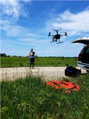
LSU graduate student Catrina Terry operates a drone as part of a research project surveying duck broods in Minnesota.
The drone contains a thermal image camera that captures heat signatures, which allowed researchers to see twice as many ducks than traditional ground survey methods.
Photo by Kevin Ringelman/LSU AgCenter

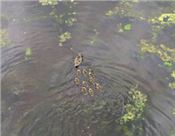
A mallard hen escorts her nine ducklings across a pond. The picture was taken by a drone as part of a project using drones outfitted with thermal imaging cameras to survey duck broods in Manitoba, Canada, and Minnesota. Once ducks were identified via thermal imaging, the drone would be lowered to take a color photograph to help identify the species.
Photo by Jacob Bushaw/LSU AgCenter